Paths
January 22, 2021 Filed under Inspiration
It is up to us whether we subordinate ourselves to god, nature, or other persons.
A saying I made up, then printed out and taped over my desk, in high school

January 22, 2021 Filed under Inspiration
It is up to us whether we subordinate ourselves to god, nature, or other persons.
A saying I made up, then printed out and taped over my desk, in high school
November 1, 2020 Filed under Inspiration
My nephew Nick and I had plans to go riding around Denmark and Norway this year, but of course, COVID-19 swept that off the table. The very idea of boarding a long-haul flight seemed crazy, even if all the flights hadn’t been canceled.
During the summer I felt stir-crazy and took a bike trip across Nevada, which went well. I was outside in hot, clean air almost all the time, far from other people, with UV radiation blasting around me. It was restorative and felt reasonably safe. But I didn’t have Nick with me, and I still wanted us to share a bike trip together.
Then in October I visited my father, and we went through a bunch of old photos, including some he took in Oklahoma when he visited the family farm over 30 years ago. The land has long since been sold, and all my extended family members moved on to other places, and my Dad no longer remembered where it was, except that it was just a few miles outside the town of Shattuck, probably to the north-west. We brought up Google Earth and scrolled around there, and used “street view” in the browser, and found some old survey maps and traced all over those trying to match the contours of the land with his photos, but could make no progress.

An old topographical map showing Pony Creek near Shattuck
The whole thing made me very curious. If I went to Shattuck, could I find someone who remembered the farm? Even if I couldn’t, could I get a feel for the land as my pioneer ancestors had known it? Nothing gives a better feel for large chunks of land in a relatively short time than a bicycle tour. Maybe this could be a trip that Nick and I take together?
Using the Reno plan as a template, I came up with a route that started and ended at major Amtrak stations and passed through Shattuck:

I pitched the idea to Nick and he was for it. We already had the hardware prepared, thanks to the canceled Denmark trip. All I had to do was drive my bike south to his, so we could board the train in Los Angeles.
Time for adventure!
I don’t know why it’s so hard to get all this information in one chart, including the relative physical sizes of the trackers, but here it is:
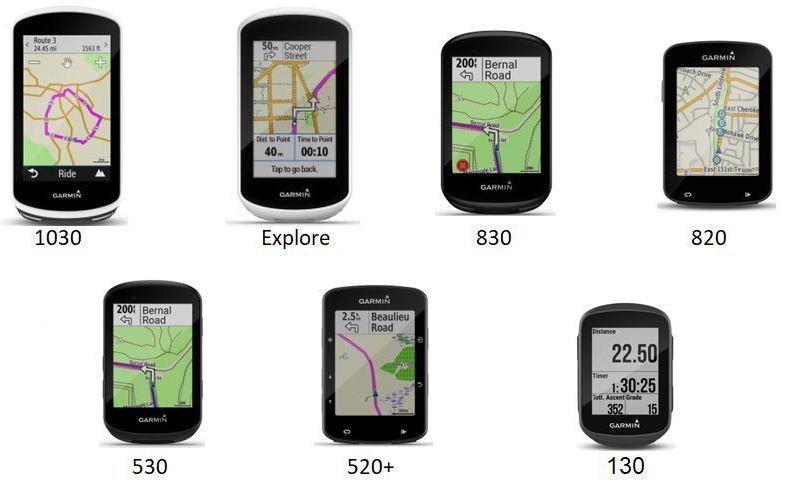
| Garmin 1030 Plus | Garmin 1030 | Garmin Explore | Garmin 830 | Garmin 530 | Garmin 130 Plus | Garmin 130 | |
| Price | 599 | 499 | 249 | 399 | 299 | 199 | 169 |
| Dimensions (mm) | 114x58x19 | 114x58x19 | 105x55x22 | 82x50x20 | 82x50x20 | 63x41x16 | 63x41x16 |
| Weight (grams) | 124 | 123 | 116 | 79.1 | 75.8 | 33 | 33 |
| Touchscreen | Y | Y | Y | Y | N | N | N |
| Screen Size (Diagonal, in.) | 3.5 | 3.5 | 3 | 2.6 | 2.6 | 1.8 | 1.8 |
| Resolution | 282×470 | 282×470 | 240 x 400 | 246 x 322 | 246 x 322 | 303×230 | 303×230 |
| Color Display | Y | Y | Y | Y | Y | N | N |
| Battery Life (Hours) | ~24 | ~20 | ~12 | ~20 | ~20 | ~12 | ~15 |
| Can Import Maps | Y | Y | Y | Y | Y | N | N |
| Has Base Maps | Y | Y | Y | Y | Y | N | N |
| Storage | 32 GB | 16 GB + microSD | 16 GB + microSD | 16 GB | 16 GB | n/a | n/a |
| Waypoints/favorites/locations | 200 | 200 | 200 | 200 | 200 | ? | 100 |
| Routes | 100 | 100 | 100 | 100 | 100 | 30 | 15 |
| Activity History (Hours) | 200 | 200 | 200 | 200 | 200 | 100 | 100 |
| GPS | Y | Y | Y | Y | Y | Y | Y |
| GLONASS | Y | Y | N | Y | Y | Y | Y |
| GALILEO | Y | Y | N | Y | Y | Y | Y |
| Barometric Altimeter | Y | Y | N | Y | Y | Y | Y |
| Accelerometer | Y | Y | Y | Y | Y | N | N |
| Wireless Connectability | ANT+, Bluetooth, Wi-fi | ANT+, Bluetooth, Wi-fi | ANT+, Bluetooth | ANT+, Bluetooth, BLE, Wi-fi | ANT+, Bluetooth, Wi-fi | ANT+, Bluetooth | ANT+, Bluetooth |
| VIRB® Control | Y | Y | N | Y | Y | N | N |
| Calories Burned Calculation | Y | Y | N | Y | Y | Y | N |
| Interval Training | Y | Y | N | Y | Y | N | N |
| Advanced Training Sessions | Y | Y | N | Y | Y | Y | N |
| Estimation Of O2 Consumption | Y | Y | N | Y | Y | Y | Y |
| Aerobic Training | Y | Y | N | Y | Y | N | N |
| Virtual Partner | Y | Y | N | Y | Y | Y | Y (On a path) |
| Virtual Racer™ | Y | Y | N | Y | Y | Y | N |
| Time/Distance Alerts | Y | Y | Y | Y | Y | ? | Y |
| Garmin Cycle Map (turn-by-turn, directions) | Y | Y | N | Y | Y | N | N |
| Works With Power Meters | Y | Y | N | Y | Y | Y | Y |
| Smart Trainer Control | Y | Y | n/a | Y | Y | Y | n/a |
My own choice among these remains the same as it was several years ago. I went from the Edge 500 over to the Edge 130 and have stayed there.
The only downside for me is that I can’t upload offline maps to it (though I can upload my own pre-made routes).
Here’s an overview of the complete route, made from stitched GPS recordings:
June 29, 2020 Filed under Curious